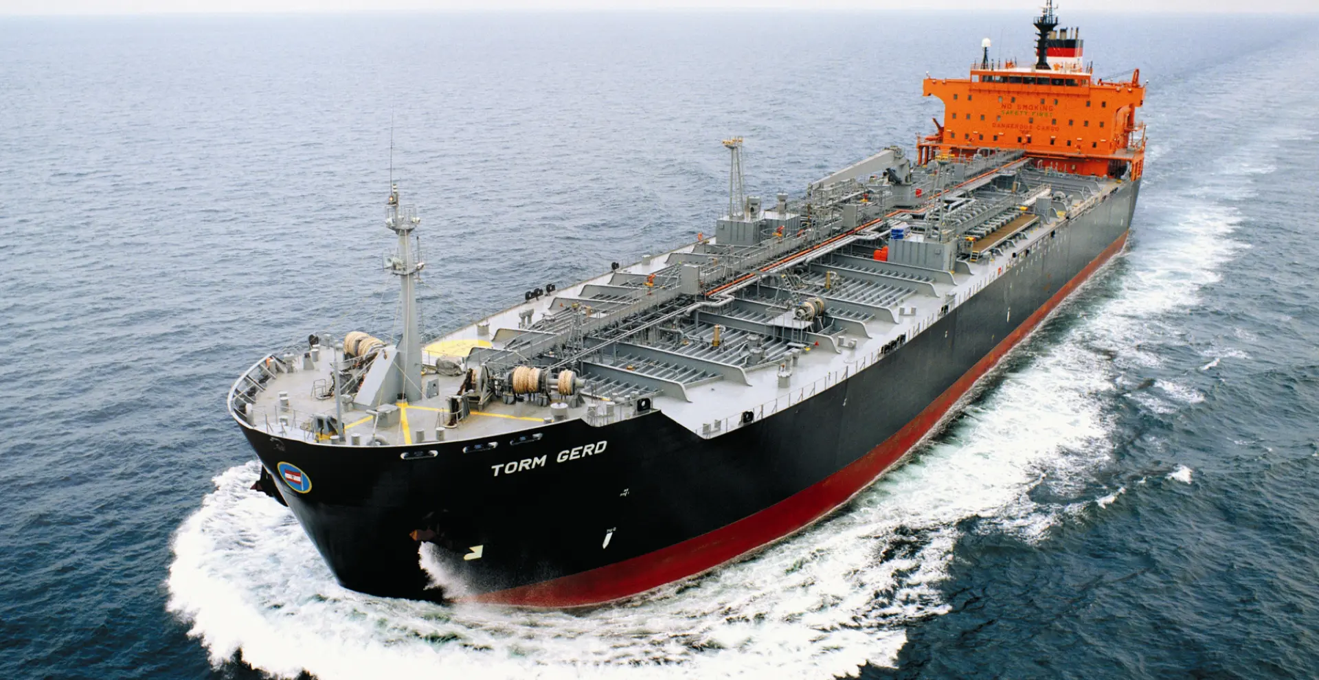
High seas
High Seas: merchant market
JRC offers integrated solutions and products for the modern high seas/merchant vessels from VLCCs to handymax, tankers, containers and bulk carriers (ships of 3000 tons and more). Founded in 1915, JRC is one of the oldest marine electronics companies and is a traditional manufacturer that has been supplying high seas/merchant ships on the High Sea for more than a century, exploring the most remote corners of the world. We have a reputation for consistently providing reliable and quality products that support ships and marine operations. This critical experience and competence is unique in the industry and enables JRC to deliver flexible solutions that look beyond current regulations. This ensures that ships are prepared for future needs and business models.
GMDSS equipment
The Global Maritime Distress and Safety System (GMDSS) was added to the International Convention on the Safety of Life at Sea (SOLAS) in 1988. GMDSS is a global emergency and safety system for shipping at sea. But what we as JRC are very proud of is that even before 1988 we were already working on safety at sea. We developed the world's first maritime radio equipment in 1915. The principle of GMDSS is to virtually guarantee that complying vessels will be able to communicate with an onshore station at any time in case of distress or to exchange safety-related information. Regardless of location whatsoever. This allows a targeted search and rescue operation to be set up with a minimum of delay. GMDSS uses a number of different maritime communication and navigation tools. The equipment a ship must have onboard depends on the sea areas where it sails.
Curious what we can do for your vessel?
If you have any questions about our products and services, please contact us via our contact form at the bottom of the page or contact one of our offices or distributors. Our team is pleased to support you with all your questions.
JRC products
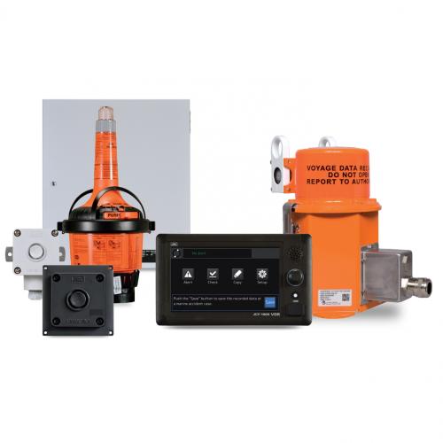
JCY-1900 VDR system
Our JCY-1900 is a black box designed. The VDR uses our own designed and fabricated, reliable, marinized hardware, with an easy IP based format, purposely designed for our VDR. The JCY-1900 has a 7-inch color LCD touch screen that enables full system control. On this LCD touch screen you can see; various VDR alerts with detailed information, which sensors are connected, and more.
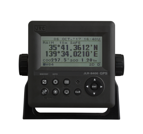
JLR-8400 Multi GNSS
The compact JLR-8400 GPS navigator is compatible with Multi GNSS and will provide accurate position data even in Arctic area, without SBAS and beacon. The newly designed multi-GNSS sensor is capable of receiving data from GPS as well as GLONASS, QZSS or BeiDou at the same time, allowing for a highly accurate positioning without beacon and SBAS.
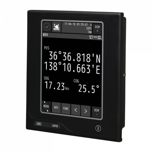
JLR-8600 Multi GNSS
The new JLR-8600 GPS navigator combined with our trusted 6.5-inch touch display will locate your position with high accuracy utilizing our newly designed antenna, providing you with the comfort of an intuitive operational approach. The newly designed multi-GNSS sensor is capable of receiving data from GPS as well as GLONASS or BeiDou at the same time.
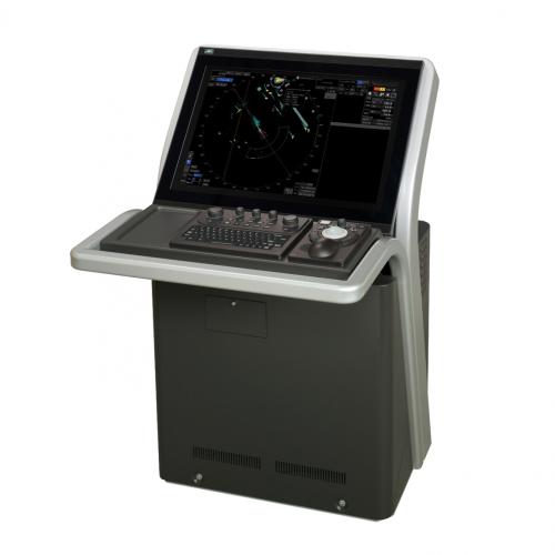
JMR-9200 Sea Radar CAT-1 MFD
The JMR-9200 is a MED-certified marine radar incorporating a 26-inch-wide and meeting the latest IMO performance standards. Incorporating a new Icon-based user interface to provide the latest functions in a user-friendly manner. And incorporates a new user interface for an intuitive menu system based on the display of icons.
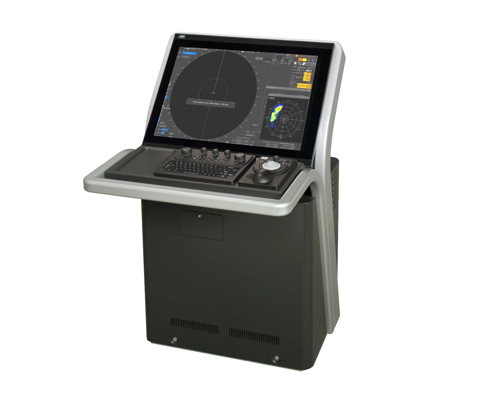
Wave Analysis
Wave Analysis function is developed to measure wave height, direction and length. Even at rough sea, clear presented information about the wave provides navigational officers a proper decision support to steer the ship on the best course and speed to reduce rolling and pitching. The analysis technique is developed in the radar signal processor, TM Blizzard, that realizes accurate wave measurement.
.png?resolution=500x0)
Based on recent developments in maritime communications, such as satellites and digital technology, GMDSS is designed to ensure maximum availability of safety-related communication for all passenger ships. The same goes for cargo vessels of 300 GT and upwards engaged in international voyages. For more advice on communication and navigation equipment best suited for your vessel please contact your JRC representative or take a look at our regulations page. View below under which products are mandatory for you in which sea areas.
| GMDSS requirements | Model | A1 | A2 | A3 Inmarsat | A3 MF/HF | A4 |
| VHF radio equipment* | JHS-800S | X (2 sets) | X (2 sets) | X (2 sets) | X (2 sets) | X (2 sets) |
| MF/HF radio equipment* | JSS-2150 | X (2 sets) | X (1 set) | X (1 set) | X (1 set) | |
| Inmarsat C | JUE-87 | X (2 sets) | X (1 set) | X (1 set) | ||
| NBDP (telex) | 7ZZJD0089 | X (1 set) | X (2 sets) | |||
| EPIRB | TBA | X (1 set) | X (1 set) | X (1 set) | X (1 set) | X (1 set) |
| SART** | TBA | X (1 or 2 sets) | X (1 or 2 sets) | X (1 or 2 sets) | X (1 or 2 sets) | X (1 or 2 sets) |
| Navtex | NCR-333 | X (1 set) | X (1 set) | X (1 set) | X (1 set) | X (1 set) |
| VHF Handheld (two-way)** | JHS-207 | X (2 or 3 sets) | X (2 or 3 sets) | X (2 or 3 sets) | X (2 or 3 sets) | X (2 or 3 sets) |
* Includes DSC and watchkeeping receiver
** >300 GT requires 1 set, >500 GT requires 2 sets
*** >300 GT requires 2 set, >500 GT requires 3 sets
High seas/merchant navigation equipment
We have many decades of navigation experience and a wealth of feedback from ship owners, navigation officers and training institutes around the world. With all this combined JRC has developed a range of navigation products to meet the needs of the market. Read more about our Multi Function Display (MFD) and NeCST solutions below, or view our other navigation products.
Multi Function Display (MFD)
The MFD solution is for ships above 10,000 tonnage. Underneath the beautifully designed units, the MFD is packed with powerful components that give you smooth graphics, fast processing and all-round serious performance. At the same time, the MFD operating system has been developed by JRC engineers to deliver one of the most intuitive and integrated maritime bridge experiences in the world. The MFD offers an incredibly easy-to-use icon based navigation experience with simple menus and dedicated functions. With a few clicks, you can do things like route planning, acquiring targets, switching between the systems or show alarm information. All-in-all, the MFD is diverse, flexible and relevant to the many markets and vessel types. It makes navigation dramatically more interactive than ever before. While having no compromise on the quality you expect from JRC.
- It complies with the latest IMO performance standards
- Ensures intuitive and easy to use display and operation performance
- The world’s first MED approved 8ft solid state scanner antenna
- Can be delivered with a software license allowing a variety of optional functions as ECDIS, Radar, Wave Analyzer, BAMS, Conning
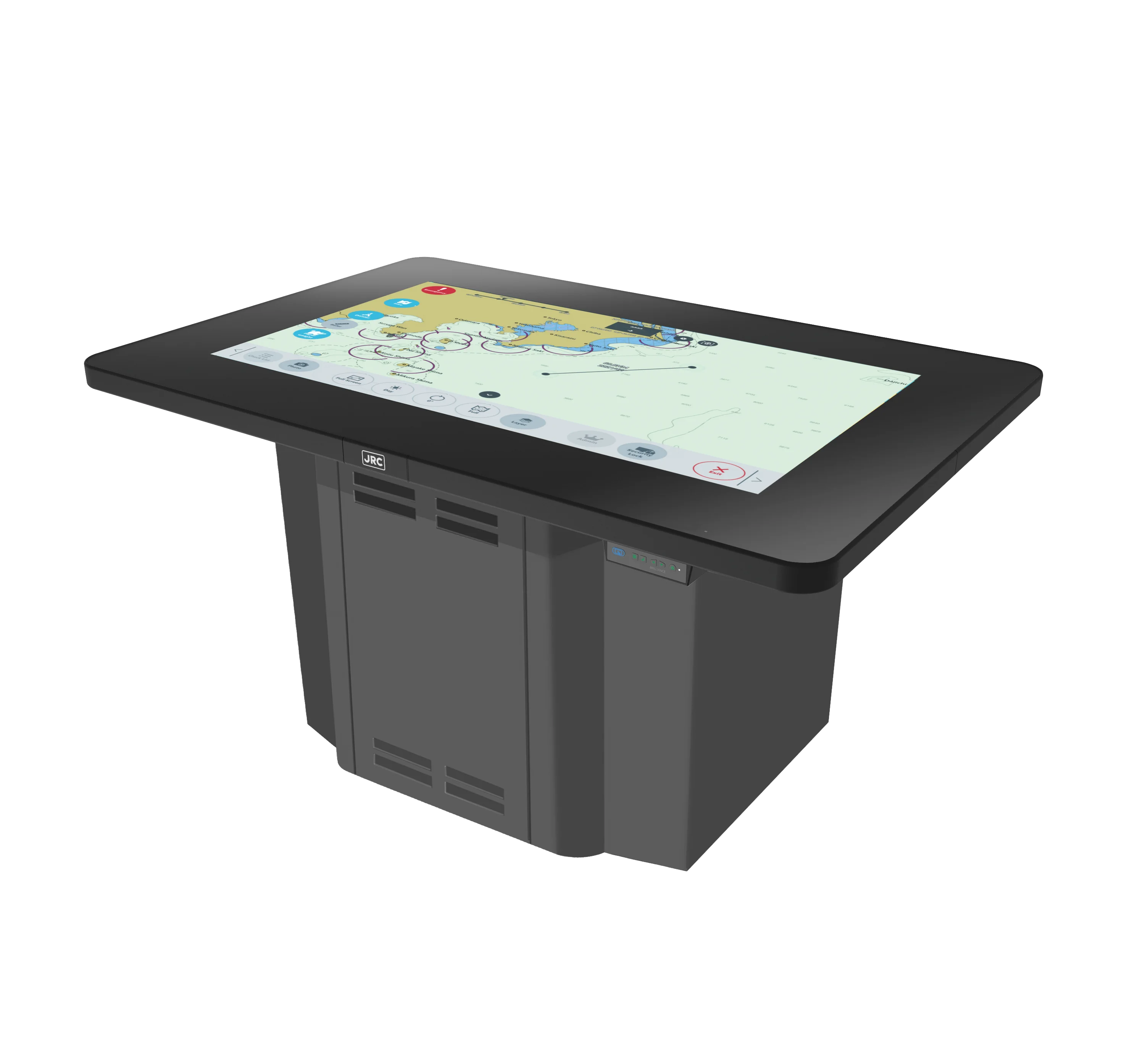
J-Marine NeCST (JAN-470)
JRC has developed a platform to support the digitalization process onboard ships. With our Navigational electronic Station Table (NeCST) you will create routes on the same paper chart scale you are used to, but now fully digital on a 46-inch touch display using your fingertips as well as smaller screens of your convenience. Interaction with the large display is just as on your mobile phone, clicking, pinching, dragging and even remarks can be added to the chart by handwriting. Routes can be created with usermaps, but also with a stylus pen or divider. The ultimate form of simple route planning.
The NeCST combined with our proprietary J-Marine Cloud will significantly enhance the operational tasks of officers onboard. This provides a total solution for safe and secure smart navigation management. It enables officers to share navigation information, such as assured routes and unavailable information on charts. Furthermore, it supplies port information (photos, notes, etc) between ships and offices. With the NeCST available for navigation, captain and officers can dramatically improve bridge operation by managing tasks more efficiently. Our NeCST is more than a Route Planning Station:
- Users can handwrite on the electronic charts
- It can share data amongst ships and land
- Route planning can be done with you fingers
- Improves daily routine on board
Satcom products
As a pioneer in developing new technologies, we are proud to have developed the world's first Marisat in 1975. Today we are proud to present our FX solution. The GX terminal is specially designed for use in the Ka-band and offers high speed, bandwidth, and worldwide coverage, lightweight but super strong. With two cables for sending and receiving signals, installation is quick and easy. With a lightweight antenna, there is no crane needed for installation which minimizes downtime. The same goes for Fleet Broadband.
Energy-saving, anti-piracy and environmentally friendly high seas / merchant solutions
For today's marine navigation, not only the safety of navigation is required, but also energy-saving navigation, environmental conservation, and anti-piracy measures. For this purpose, ships on voyages need accurate navigational aids from the shore. The J-Marine GIS is designed to acquire, manage, analyze and indicate or display a diversity of information. This includes ship status, meteorological/oceanographic, vessel traffic information for ship navigation and operation in an efficient and integrated manner using JRC's in-house technology. The J-Marine GIS will cope with various problems in marine navigation to provide appropriate solutions to them, contributing to R&D support, training of personnel, supervision of ship navigation, and marine business support.